

|
||||||||||||||||||||||||||||||||||||||||||||||||||||||||||||||||||||||||||||||||||||||||||||||||||||||||||||||||||||||||||||||||||||||||||||||||||||||||||||||||||||||||||||||||||||||||||||||||||
UKHO ECDIS ServiceThe Admiralty ECDIS Service is the first global system of navigation combining official vector charts with official raster charts that is safe, accurate and easy to manage from UKHO with their unrivalled reputation for quality and excellence. Electronic Navigational Charts used in the ECDIS system are the most advanced nautical charts available in vector format using data from IC ENC and Primar; they are issued only on the authority of a national hydrographic office, and provide the most comprehensive and current chart information available. The other component, Admiralty Raster Charts or ARCS are high quality, digital versions of the world renowned British Admiralty series of paper charts. They are widely used by the commercial shipping industry and comply with the exacting Raster Navigational Chart (RNC) performance standards set by the IMO which mandates that ARCS can be used with Flag State approval, for primary navigation where ENC’s are not yet available. Moreover ARCS is also a preferred chart for planning purposes. The UKHO compares both coverage and scale of ARCS charts with all newly released ENCs and automatically replaces ARCS with new ENCs as their coverage increases, eliminating the apprehension of unpredictable pricing or the burden of heavy administration associated with use of ENCs. The ENCs used in the Admiralty ECDIS Service meet SOLAS carriage requirements when kept up to date and used within an ECDIS with suitable back up. They are 100% official. Regulations governing the use of ENCs and ECDISIMO SOLAS Chapter V, Regulation 19, 2.1.5
|
||||||||||||||||||||||||||||||||||||||||||||||||||||||||||||||||||||||||||||||||||||||||||||||||||||||||||||||||||||||||||||||||||||||||||||||||||||||||||||||||||||||||||||||||||||||||||||||||||


|
|
|
|
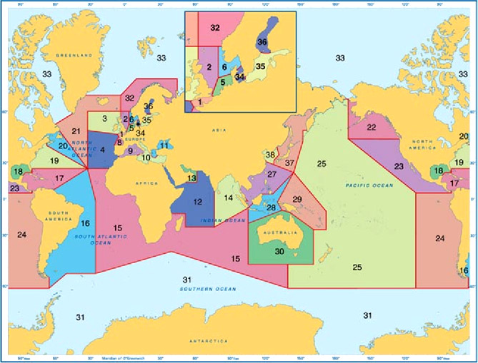
ENC coverage is continuously growing and we will continue to keep you updated as coverage improves. Please note that ARCS coverage is now available in all areas other than Japanese, Ecuadorian and larger scales in Malaysian waters.
Geographic Areas
Chart coverage in the ECDIS service is provided in 38 geographic areas - each geographic area containing ENCs, where available, together with comprehensive ARCS coverage. The geographic areas have been designed to simplify both the ordering process and pricing of the new service, whilst minimising the number of ENCs and ARCS charts the shipping company must purchase.
Hyperlink Digital Catalogue.
Operational Folios.
Within each area there are up to three separate levels of chart coverage for ease of selection, use and cost effective flexibility.
- The Transit Folio contains the ENCs and ARCS charts required for safe transit through a geographic area, including principal ports, primary routes, bunkering ports and ports of refuge and excluding all other charts.
- The Standard Folio contains the ENCs and ARCS charts required for operational use, including all key ports and approach charts in that geographical area. Remote anchorages, ports of less than 10 meters in depth, naval bases, ports where port calls are few, bulk cargo only ports, low throughput container ports, very small crude oil loading ports and low volume oil product ports are all excluded.
- The Full Folio contains all ENCs and ARCS charts available for the geographic area.
These folio categories have been designed to appeal to passenger liners, container ships, crude oil tankers, product tankers, chemical carriers, gas carriers and all ferries. It is anticipated that these folios will not be as well suited to naval vessels, non-SOLAS tonnage, bulk carriers, coastal traders or pleasure craft.
The ENC content in each folio is increasing rapidly as the UKHO actively seeks to extend coverage through close cooperation with other official producers of ENCs. With growing coverage there has been a 20% price increase in the price of Folios as stated here.
| Folio | Full | Standard | Transit | |
| 01 | English Channel | £1,360 | £604 | £535 |
| 02 | UK East Coast | £1,169 | £640 | £495 |
| 03 | Ireland & UK West Coast | £1,631 | £565 | £498 |
| 04 | Western Approaches & South to the Canaries | £900 | £450 | £400 |
| 05 | Belgium, Netherlands & Germany | £411 | £303 | £201 |
| 06 | Norway & W Denmark to Skagerrak | £3,000 | £1,150 | £850 |
| 08 | Bay of Biscay | £900 | £650 | £400 |
| 09 | Mediterranean West | £2,200 | £900 | £600 |
| 10 | Mediterranean East | £2,583 | £1,236 | £684 |
| 11 | Aegean & Black Sea | £2,375 | £936 | £633 |
| 12 | Red Sea, Arabian Sea & NW Indian | £2,850 | £1,433 | £699 |
| 13 | The Persian Gulf & Oman | £564 | £499 | £270 |
| 14 | Sri Lanka & Bay of Bengal with Malacca, Singapore & Sundra Straits | £2,126 | £860 | £759 |
| 15 | West Africa to Madagascar | £1,150 | £700 | £450 |
| 16 | East Coast South America | £649 | £368 | £192 |
| 17 | Caribbean | £1,133 | £766 | £404 |
| 18 | Gulf of Mexico | £543 | £399 | £211 |
| 19 | United States East Coast | £800 | £500 | £350 |
| 20 | Eastern Canada | £3,121 | £1,487 | £1,050 |
| 21 | Greenland to Faeroes | £310 | ||
| 22 | Alaska to Vancouver & Seattle | £2,277 | £1,263 | £904 |
| 23 | West Coasts USA & Central America | £548 | £309 | £271 |
| 24 | West Coast South America | £1,632 | £947 | £466 |
| 25 | Pacific | £1,323 | £537 | £424 |
| 27 | China Seas & Philippines | £2,969 | £1,678 | £1,180 |
| 28 | East Indies | £683 | £419 | £286 |
| 29 | New Guinea to Vanuatu | £400 | ||
| 30 | Australia | £1,282 | £726 | £504 |
| 31 | Antarctica | £200 | ||
| 32 | Norway to Russia | £5,947 | ||
| 33 | The Arctic | £2,271 | ||
| 34 | Kattegat to Rugen | £1,474 | £656 | £482 |
| 35 | Central Baltic & Gulf of Finland | £5,050 | £2,550 | £2,100 |
| 36 | Saaristomeri & Gulf of Bothnia | £2,500 | £1,200 | £500 |
| 37 | Japan & Sea of Okhotsk | £2,718 | £1,486 | £1,003 |
| 38 | Republic of Korea & Yellow Sea | £3,893 | £1,624 | £1,138 |
Additional Folios purchased during the licence period are charged at the following rates:
| Elapsed time | Price per folio |
|
|